|
||||||||||||||||||||||||||||||||||||||||||||||||||||||||||||||||||||||||||||||||||||||
The founding of Constantinople
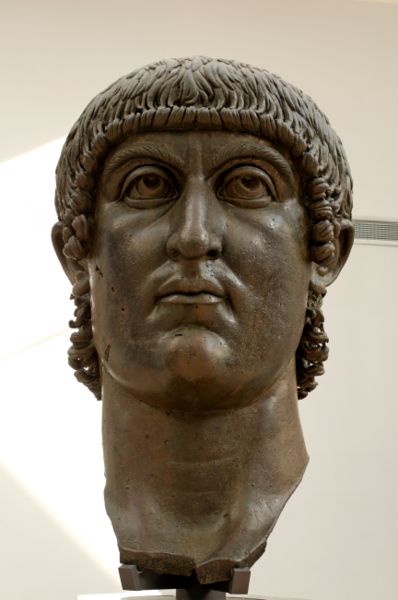
Constantinople, now Istanbul, takes its name from the Roman emperor Constantine the Great. ( 272- 337) In 324 Constantine moved the capital of the Roman Empire eastwards to this site, then called Byzantium, where Europe gazed over into Asia.
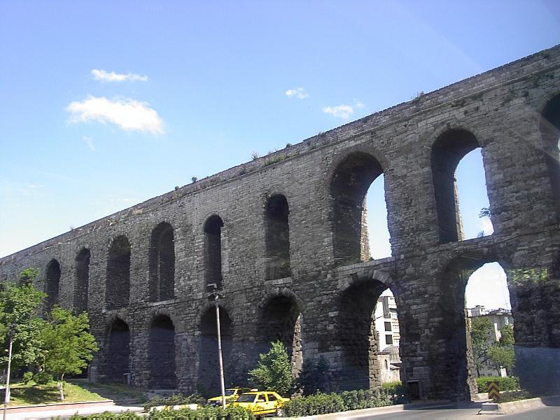
The new capital was built on a strategic position between Asia and Europe (from ancient times the Bosphorus has been conventionally regarded as separating Europe from Asia ). in a promontory at the southern end of the Bosphorus, near the strait that connects the Sea of Marmara to the Black Sea to the north east and the straits of Dardanelles to the south who give access to the Aegean and the Mediterranean. To the immediate north of the old city is a narrow bay called the Golden Horn.It is one of the finest natural harbours in the world and runs inland for almost seven miles. This was one of Constantinople's most priceless assets. The location of Constantinople, bridge between east and west, give to the site a strategic position This considerations led to Byzantium being chosen as the new capital in the first place. But Byzantium exist 1000 years before the birth of Constantine For the great historian Polybius,( 210 BC 126 BC) Byzantium may have been favored for security and prosperity by the sea because she was vulnerable from the land until the construction of the great walls But in spite this vulnerability Byzantium become a considerable economic settlement . He was the gateway for trade in and out of the east and West and Europe and Asia The most important of this traffic was centered on food. Egypt receive corn until the 7th century AD from the Dardanelles But this prosperity arouse desires so for his defense Byzantium would be built fortifications Impregnable by nature to north, east and south she has no natural protection on the western approach The solution to the problem of security from the west was the construction of the walls Repaired and extended over centuries, the walls of Constantinople withstood sieges delivered by different Armies with different weapons and techniques for over a millennium. Now they were partly ruined and partly restored The first fortifications of Constantinople. So, in the year 328 when Constantine the Great with his experienced of soldier had choose Byzantium into as capital, he has first studies the position of this city geographically, economically and Strategically . After this 3 elements he see the defenses of the future empire capital. The New Rom Some defensive walls had existed from ancient times, but Constantine immediately arranged for new walls to be built. First he built an important land wall from the Golden Horn (Χρυσοῦν Κέρας) to the Sea of Marmara. The limits that his new walls now enclosed trebled the area formerly occupied by the old Greek city. The original fortifications of the city were built in the 7th BC when it was founded Byzantium by Greeks colonists from Megara. Byzantium, was relatively unimportant despite being a prosperous trading post, She toke and important part only during the civil war between Septime Severe(146- 211 ) et Niger (140 194) Septime Severe put siege for three years (193-96 ) before Byzantium . As punishment, Severus had the strong walls demolished and the city deprived of its status. However, appreciating the city's strategic importance, he rebuilt and endowed the city with many monuments. No details are known of the Severan Wall, except its general course and that its main gate was located shortly before the entrance of the later Forum of Constantine. The rebuilding of the city as the new imperial capital inevitably encouraged a substantial growth in population. One happy result of this was that when the invading Goths appeared before Constantine's wall in 378, following their victory at the battle of Adrianople, they were dissuaded from attacking the city because of the evidence of such a large multitude to oppose them. But the growing population could not forever be housed conveniently within the confines of Constantine's original city plan. Such was the demand for building plots for housing alone that areas of land were reclaimed from the sea. On a larger scale Emperor Valens (328-378), for example, erected the fine aqueduct that bears his name in the 4th
century This was an enormous project, the scale of which can be gauged from the fact that when it was repaired during the 9th century 6000 labourers had to be brought in for the purpose. By the time of the reign of Emperor Theodosius II (408-450) the city was threatening to burst the confines that Constantine had erected. Something had to be done, but by the first half of the 5th century the population explosion in Constantinople was not the most important consideration occupying imperial minds.
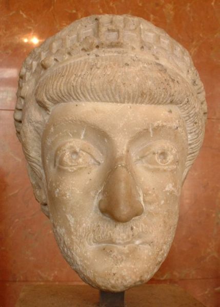
Rome, the former capital of the Empire, had been captured by the Goths. The Huns had also crossed the Danube, and although they had been driven back there was a real fear that they would return to pose a direct threat to Constantinople. It was therefore most fortunate for the Byzantine Empire that when the hour came, along too came the man. His name was Anthemius, and he headed the Byzantine government during the minority of Emperor Theodosius II. From thetime of his appointment as Praetorian Prefect of the East in AD 405, Anthemius( He was the head of state for six years during the minority of Theodosius ) applied himself with vigour to whatever task the empire demanded of him. The first task was the expulsion of the Huns from the Balkans. The second resulted in the walls of Constantinople. The so-called Theodosian walls (nothing so grand could bear the name of anyone less than the ruling emperor) were the results of Anthemius' skilled and dedicated work. His walls set in stone the limits that Constantinople was to possess and to defend until modern times. Today's tourists to Istanbul find Anthemius' limits marked on the map as the 'Old City': an apparently tiny element in the modern sprawl that now stretches far up the Bosphorus past the two recently built suspension bridges. But that sprawl is modern Istanbul. The Theodosian walls defined what for the next 1,500 years was to be understood as Constantinople. The Theodosian walls
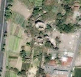
It was the capture of Rome by the Visigoths in 410 that forced the Byzantine government to build a fourth wall, which is called the Theodosian Wall, and is about 1½ km wall of the wall of the original walls of Constantinople. The area occupied by the city was therefore greatly increased,and as Rom with the Theodosian walls Constantinople enclosed seven hills. The wall was built in 412-414, surrounded an area of 12 km², was 12 m high, and had 96 towers that were about 18 m tall. Then under the direction of the Praetorian Prefect of the East Anthemius began maintenance and repair of the hold fortifications and the erection, of new fortifications for the city .All citizens were required to assist in one form or another. On that point the laws were very strict, and neither rank nor privilege exempted Anyone from their obligation to carry out the work. One-third of the annual land tax of the city went towards the cost of the walls, and any additional expenditure was provided by requisitions laid upon the inhabitants. But for Constantinople resident this project is a assurance of security,. At this point of view government exploit this enthusiasm in various ways. The citizens' generosity With the rivalty between circus faction .The Blues and the Greens This 2 factions work together for the walls and in 447, Blues and Greens supplied 16,000 men when, when repairs were being undertaken, The walls designed by Anthemius were completed in 423, the fifth year of the reign of Theodosius II, They survive today as the inner wall of the fortification line that extends from the Sea of Marmara to the ruins of the Palace of the Porphyrogenitus (Tekfw Sumy). Whith the increase in the area they necessitated an extension of the sea walls along the northern and southern shores of the city,although these works were not carried out until some time later. But in 447, great part of the new walls, including 57 towers, were hit by a earthquakes. In the same time appear Attila danger the Hun were advancing to Constantinople. But with citizens aid the government restore the fallen walls in less than three months. These new walls save Constantinople from Attila (406-453),We don’t know the name of this foreman Perhaps Constantine or Cyrus,the Praetorian Prefect of the East. During this restoration s he took the opportunity to make the city into a much stronger fortifications. An extra wall was built outside Anthemius' wall, with a broad and deep moat in front of it. When the work was complete the city lay behind three lines of defense and 192 towers flanked the walls. The next walls Just before they head downhill towards the Golden Horn, the Theodosian walls come to an abrupt end and are replaced by a wall of more complex and different construction. This explanation begins in 627 during the reign of Emperor Heraclius when the quarter called Blachernae was actually a suburb outside the line of the Theodosian walls. And this place we found a sacred aera with the Church of the Theotokos,or Mother of God,who contain relics In 627 during the Avars attack against Constantinople this aerea was devastated So the church was prompted protect by the realization of walls and little after Blachernae Palace received protection of a wall in 813 under Emperor Leo the Armenian for facing to Bulgarians threats The imperial palace of Blachernae, became the favorite residence of the imperial court during the reign of Alexius I Comnenus (1081-1118). But it is one of Constantinople's most important buildings. its remain a prime target for any attack, so there was a constant need to review the defences Additions were therefore made, and the walls that now surround the Blachernae Palace area are the walls built during the reign of Emperor Manuel Comnenus (1143-80). These construction were the final pieces of the jigsaw that now make up the walls of Constantinople. Design and development
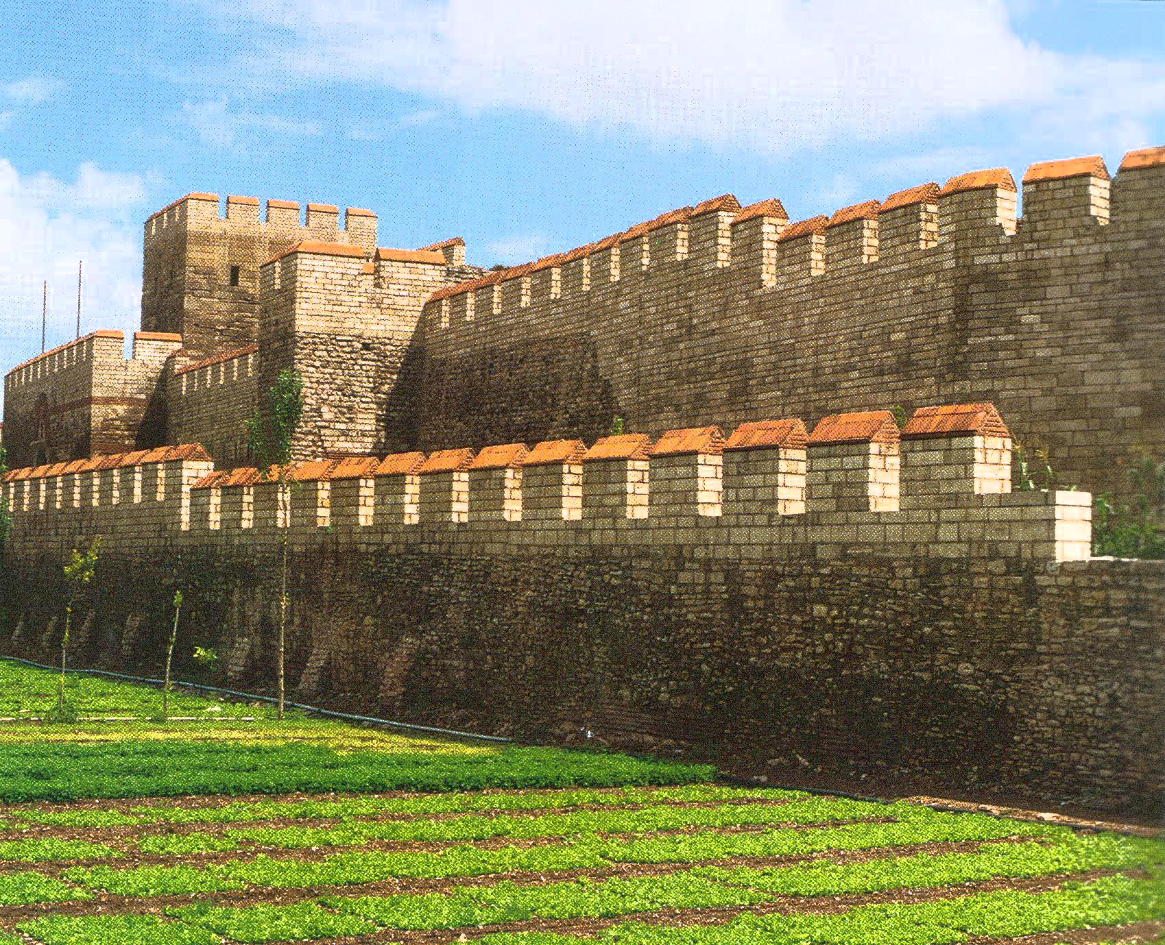
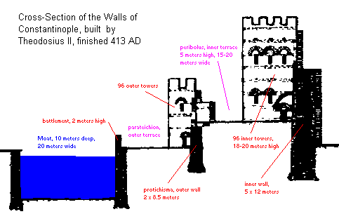
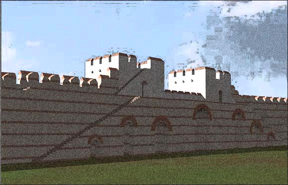
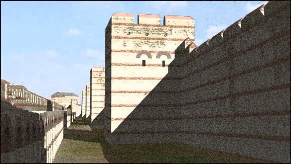
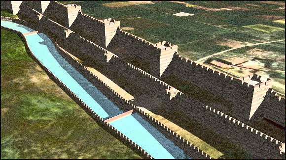
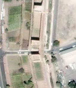
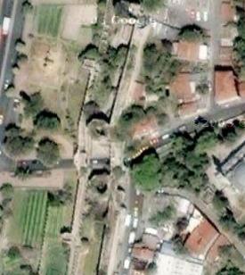
The material structure of the walls Theodosian walls of Anthemius reveals three layers of defense. From the city side outwards, there is the inner wall. A narrow walkway divides this from the outer wall, which is both lower and weaker. A wider outer walkway ends with another low wall that is the inner side of the moat. On the other side of the moat the ground is flat. The foundations of the walls will be like the other byzantine constructions constructed of brick or stone cramp on the bedrock The standard building materials of this walls were squared stone, brick and lime mortar. Sometime you found Marble,(take from old monuments like at Rom ). The stone came from the region because around Marmara Sea we found rich variety of natural stones, and numerous quarries.( located about 5 kilometers to the west of the Golden Gate. ) Bricks must have been produced locally, in kilns and mortar was made by mixing lime with various aggregates, often brick dust and fragments. Byzantine mortar was particularly strong once it had hardened. Decoration stone were some time used for exemple for a gate or and inscription were took upon and hold monument . For construction walls were generally made in alternating bands of brick and stone. Squared stone faced both the inner and outer surfaces of the wall, and mortared rubble filled the space in between the facings. The bricks a leveling course, extending through the thickness of the walls and binding the two faces together, so that when a brick course appears on the outside of a wall, we should expect to see the same course on the inner. In the inner wall six brick courses, each containing five layers of bricks, were laid at intervals through the thickness of the walls to bind the structure more firmly. The bricks used are sometimes stamped with the name of their manufacturer or donor, and occasionally bear the name of the contemporary emperor and some indication of where they were made. The inner wall
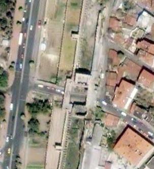
The inner wall is the strongest part of the wall. This wall is still visible either as ruins or modern reconstruction, stood on a higher level than the outer wall and was loftier, thicker and flanked by towers. The inner wall rises some 9.5m above soil and about 12.5m above the level within the city, with a thickness varying from 4.75m near the base to 4.15m. at the top. A pathround of 1.2m row along the outer edge this was the main defensive platform, and was reached by flights of stone steps set at right angles to the wall above ramps of masonry. 96 towers originally were built. First they were spaced all 53 mand after all the 18 m. They are height from 5.5 m to 10.3 m. Most are of square but some were hexagonal, heptagonal or octagonal. Is towers were part of the same construction; they were built as separate structures. each tower is divided into two chambers wih wooden or vaulted floors. The lower chamber was entered from the city by a large archway. This entrance provided most of the light and air for the room, because defensive considerations did not permit large windows. This chamber serves as a storeroom or guardhouse. In some cases a narrow postern gate in the angle of the wall allowed access to the walkway between the two sets of walls. For further security considerations, the lower room had no means of communication with the room above. This was instead entered only from the pathround level by an arched doorway. The upper room was well lit by comparatively large windows that allowed the defenders a good field of view and also permitted them to fire freely upon attackers. A flight of stairs allowed access to the third and defensive level of the tower. This was the battlemented roof. In times of siege catapults, and later cannon, could be mounted. In resume with are 3 levels and the thickness of this wall with the separate structure the towers were ensured (theoretically) against crumbling. The outer wall The terrace between the inner and outer walls was called peribolos, and accommodated soldiers who defended the outer wall. It was between 15.2m and 18.2 m wide. Beyond lay the outer wall, which was a modest structure compared to the inner wall. If he was not a vital line of defense, he play a decisive role during the last sieges in 1422 and 1453 The outer wall is from 06.0cm to 1.8m thick, rising some 3m above the level of the peribolos and about 8.41m above the present level of the terrace between the outer wall and the moat. Its lower portion is a solid wall that retains the embankment of the peribolos. The upper portion is built for the most part in arches, faced on the outer side with hewn blocks of stone, and is frequently supported by a series of such arches in concrete. The arches strengthened the wall and allowed the construction of a battlement and parapet walk on the upper surface. The arches also formed chambers 2.62m deep where soldiers could be safely sheltered and accommodated. The towers in the outer wall are much smaller than those in the inner wall. They are high from 9.14m to10mt stick out about 4.87m beyond the curtain wall, They are spaced out so as to alternate with the towers of the inner wall. At the origin they were designed in alternate shapes of squares and crescents, but after later repairs the pattern will be spoiled. Each tower had a chamber on the level of the peribolos that was provided with small windows. The lower portion of most of the towers was generally a solid substructure, but in the case of the square towers it was often a small chamber reached from the outer terrace by a small postern gate and leading to a subterranean passage running towards the city. The outer terrace and moat
The terrace between the outer wall and the moat is about 18m wide. It was known as the parateichion, and its main function was to extend the distance between the besiegers and the besieged. The moat is over 18 wide and over 6m deep. On the scarp and counterscarp there is masonry 1.5m thick, and buttresses support it. The small defensive wall on the scarp is about 2.2m.high. Across the moat are found long low walls that appear to divide the moat into several compartments. These contain hidden aqueducts for the supply of water to city. The gates of the city
The Theodosian walls were pierced by ten main gates and several small postern gates. Postern gates were few in number for security reasons and almost all were different parts of the fortifications and the public gates that were the entrances to the city by means of bridges across the moat. The two series followed each other in alternate order, the military entrances being known by numbers and the public gates by proper names. Both the public and the military gates shared a common overall design. All were double gateways because they had to pierce two walls. The inner gateway, being the principal one, was built into the inner wall of the Theodosian wall Two large towers that projected far beyond the curtain wall guarded all the gateways. The towers were of very similar design to the towers found along the length of the walls Belgrade Gate provides an excellent example of this, showing how the projecting walls would allow defenders to achieve good flanking fire and to protect the outer gateway by archery. The other intention behind the design was that the distance across the peribolos between the two sets of gates should be made deliberately as narrow as possible. By contrast, the gates in the outer walls were quite modest affairs, consisting of a simple gated arch not much higher than the outer wall level. The sea walls
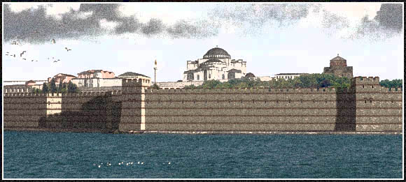
The sea walls enclosed the city on the sides of the Propontis or Sea of Marmara and the gulf of the Golden Horn . Although the original city of Byzantium certainly had sea walls, traces of which survive, the exact date for the construction of the medieval walls is a matter of debate. , the first actual reference to their construction comes in 439, when the urban prefect Cyrus of Panoplis was ordered to repair the city walls and complete them on the seaward side. Nevertheless, the walls are not specifically mentioned as extant until much later, around the year 700
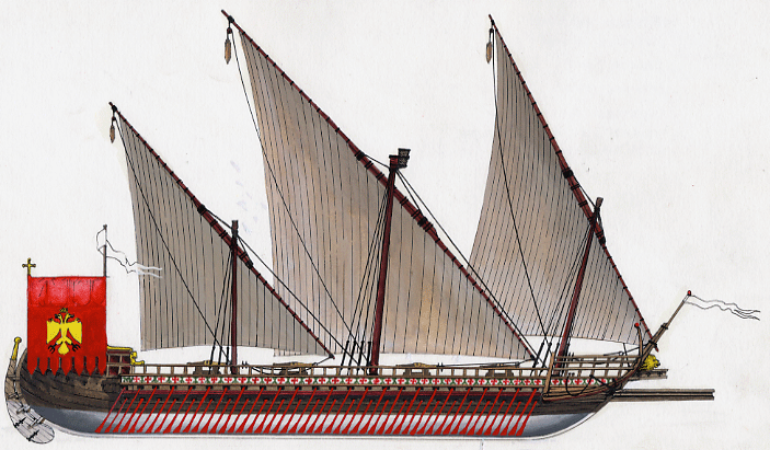
The sea walls were also important for the city so Constantine I and Theodosius II make important constructions not as mighty, as the Inner and Outer wall but powerfulThe sea walls of Constantinople were extent less important in the city's defense. As long as Byzantine sea power was a realty the city has not to be afraid by threat coming by sea (Bosphorus and Dardanelles Straits). This sea power was menaced with the Ottomans and the Italian republics like Venice Genoa . Byzantine engineers provided the tactical solution for the northern shore of the city in the form of the famous barrier chain At this point the currents in the Sea of Marmara are strongs and they could always carry an attacking fleet out to sea or fling it against rocks. Made of giant wooden links that were joined by immense nails and heavy iron shackles, the chain could be deployed in an emergency by means of a ship hauling it across the Golden Horn from the Kentenarion Tower in the south to the Castle of Galata on the north bank She was supported in the water by wooden floats. Securely anchored on both ends, with its length guarded by Byzantine warships at anchor in the harbor, the great chain was a formidable obstacle and a vital element of the city’s defenses.
It is first mentioned in 717-18 when Emperor Leo l (701-774 )powered the chain in the hope of enticing the enemy fleet into the harbour. It was also used by Nicephorus Phocas(912-969) against an expected Russian attack in 960 She was used in 1203 because crusading army has captured and destroyed the northern anchor point In1351 during the war against l Genoa Constantinople after the capture of the fortified town of Heraclea in view of the enemy's approach put the sea walls in order, repairing them where they were ruined, raising their height and ordering all houses in front of them to be removed. He also increased the height of the towers
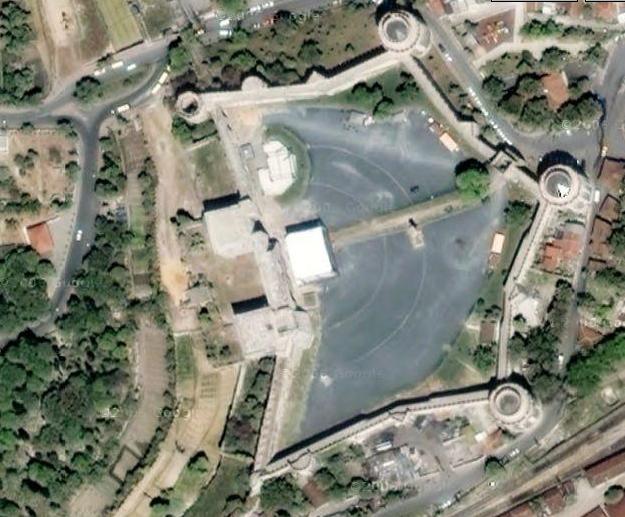
And in 1453 Mehmet the Conqueror (محمد الثانى 1432 1481 ) use and other ingenious and successful method of dragging his ships overland. It was the first and the only one successful naval assault on Constantinople. Visit to Theodosian Wall The Theodosian Wall haves almost 5½ km long. It begins on the shores of the Golden Horn, near the Blachernae Palace, and continues to the South, to the Golden Gate -which was included in the new Wall- and Sea of Marmara. There are many gates The Gates
1. the First Military Gate ( or Gate of Christ ) now Tabak Kapi named because of the Cryptogram inscribed on it,
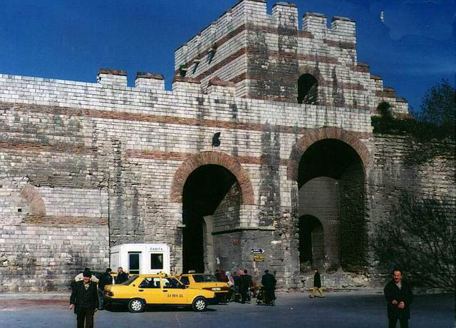
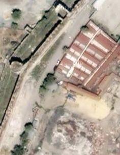
2. the Golden Gate ( Porta Aurea,) now Yedikule Kapi which was a triumphal arch from the reign of Theodosius I, originally standing alone, outside the Constantinian Wall, over the Via Egnatia. She was one of the greatest pieces of military architecture ever, and she was built between 412 and 414, and It was incorporated in the Theodosian Walls in 447 further expanded by another praetorian prefect of Theodosius's, Cyrus of Panopolis. She serve as the state entrance into the capital, especially for the occasions of a triumphal return of victorious emperors from battle. It was architecturally elaborate, built of large square blocks of polished marble fitted together without cement, with three arches. During later years, two great flanking towers of the same material were added The gate was later included in a fort with five towers by the emperors John I Tzimiskes (969-976) and Manuel I Comnenus (1143-1180). It was partly demolished when the Crusaders sacked Constantinople in 1204, but restored by John VI Palaeologus (1347-1454) and his regent and successor John V. The name Heptapyrgion, "the seven-towered bulwark", dates from this time. The fort was destroyed for the second time in 1391, when the Ottoman sultan Bayezid I ordered the emperor to do so, threatening with harsh measures against John V's captive son. After Mehmet II the Conqueror had become master of Constantinople in 1453, he rebuilt the Heptapyrgion; the Turkish name Yedikule is a translation of "seven towered bulwark". It was used as the Ottoman state treasury until 1789. Upon the gates were placed sculpted bronze elephants, flanked by winged Victories. Since the main Gates were usually kept closed, a smaller gate exists after the Fort, the Small Golden Gate modern Yedikule Kapa , which was used for everyday traffic.
3. the Second Military Gate the greatest of the military gates. Now Belgrade Kapi , after the Serbian artisans settled there by Sultan Suleiman the Magnificent after he conquered Belgrade in 1521.
4. the Gate of Melantias (Porta Melantiados or Selymbria Gate now Silivri Kapi also known as Zoodochos Kapa after the monastery outside the Walls, where the forces of the Empire of Nicaea under General Alexis Strategopoulos entered and retook the city after and reconquest upon Latins on July 25th 1261.
5. the Third Military Gate at the section known as the "Sigma", today
6. the Gate of Rhegium now Yeni Mevlevihane Kapi Gate of the Reds, because it had been repaired in 447 by the Reds faction of Hippodrom.
7. the Fourth Military Gate now Millet Jaddesi.
8. the Gate of St. Romanus , named so after a nearby church, now is called Topkapi or Cannon Gate today, because of the great cannon that was placed opposite it during the last siege of Constantinople. Emperor Constantine XI established his command here, at the central and most threatened stretch of the walls
9. the Fifth Military Gate now called Hüjum Kapi or Assault Gate Turkish, because there the decisive breakthrough was achieved on the morning of May 29, 1453.
10. the Gate of Charisius (Porta Charisiou or Polyandrion Porta named so because it led to a cemetery outside the Walls), now Edirne kappi or Gate of Adrianople where Mehmet II made his triumphal entry into the conquered city. This gate stands on top of the sixth hill, and was the highest point of the city at 77 meters. At the very end of the Theodosian Walls is the postern called the Xylokerkos Porta or Kerkoporta, after a wooden circus (amphitheatre) that existed there. This gate was left open on the fateful 29 May, apparently accidentally but possibly through treachery, and through it the Janissaries first entered the city. A large plaque today marks the spot. I have described the Theodosian Wall upper now We found the Mesoteichion or Middle Wall
Chronology 324 Constantine moves the capital of the Roman Empire to Byzantium 325 New walls are built 378 Battle of Adrianople 405 Anthemius begins the Theodosian Walls 423 Completion of the Theodosian Walls 447 Much of the walls destroyed by an earthquake 626 Siege by the Persians and Avars 627 Building of the Wall of Heraclius 674 Siege by the Arabs begins 678 Use of Greek fire ends the Arab siege 714 Second siege by the Arabs 813 LeoV adds outer wall in Blachernae Quarter. Siege by Krum the Bulgar 860 Siege by the Russians 1047 Siege by Leo Tornices 1081 Alexius Comnenus enters Constantinople 1097 First Crusade threatens Constantinople 1204 Fourth Crusade takes Constantinople 1261 Constantinople recaptured from the Latins 1345 Extensive repairs carried out to walls 1351 Repairs to sea walls 1390 First use of gun powder at Constantinople 1396 Siege by Bayezid the Thunderbolt. Battle of Nicopolis 1422 Siege by Murad II 1444 Battle of Varna 1453 Constantinople falls to Mehmet the Conqueror Thank to Nuray |
|
Droit d’auteur La plupart des photographies publiées sur ce site sont la propriété exclusive de © Claude Balmefrezol Elles peuvent être reproduites pour une utilisation personnelle, mais l’autorisation préalable de leur auteur est nécessaire pour être exploitées dans un autre cadre (site web publications etc) Les sources des autres documents et illustrations sont mentionnées quand elles sont connues. Si une de ces pièces est protégée et que sa présence dans ces pages pose problème, elle sera retirée sur simple demande. Principaux Collaborateurs:
Nb
de visiteurs:9469413 Nb
de visiteurs aujourd'hui:684 Nb
de connectés:35
| ||||||||||||||||||||||||||||||||||||||||||||||||||||||||||||||||||||||||||||||||||||


.jpg)
.gif)
.gif)
.jpg)
.jpg)

(1).jpg)

.png)